|
Residents across the Rideau Valley Watershed are being urged to prepare as a significant storm approaches this weekend, bringing a mix of snow/ice, freezing rain, and possible rainfall. The combination of this storm and already elevated water levels due to the early spring thaw is increasing the risk of localized flooding in low-lying areas.
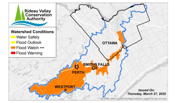
A Flood Watch is being issued for the lakes in the Upper Watershed, particularly Bobs Lake and Christie Lake, and along the Rideau River from Smiths Falls to Manotick (Long Reach).
This Flood Watch statement is in effect until April 04, 2025 at 11:59 pm or until an update has been issued.
More Details:
Weather Forecast: Environment and Climate Change Canada is forecasting a significant mixed precipitation event for this weekend, with possible additional rainfall into next week. Significant freezing rain and snow accumulation are expected for Saturday and Sunday, with possible ice accretion exceeding 20 mm for some regions, and snowfall/ice pellet accumulations of 10-30 cm. The exact form of precipitation is uncertain and could transition to rainfall throughout the event, with locally higher amounts possible. Temperatures are expected to rise quickly by early Monday morning, with highs of 12-14°C across the Rideau Valley watershed.
Environmental Conditions: All water levels and flows across the Rideau Valley Watershed remain elevated due to the ongoing early freshet, with the upper watershed reservoirs having limited capacity remaining to absorb additional melt or rainfall. While only minor snowpack remains across the jurisdiction, meltwater is still moving through the landscape, continuing to contribute to rising water levels in some regions.
Risks: Portions of the Rideau River are under a flood watch, with localized areas under increased flood risk, based on the following factors:
- With the uncertainty of the temperature, precipitation types and accumulation in the forecast, additional melt and/or rainfall may contribute to further increases in water levels and flows.
- With limited capacity remaining within the upper reservoirs, increasing water levels may exceed full supply levels and result in flooding within low-lying areas.
- With the risk of significant ice accretion (freezing rain), utility outages are possible.
Location-Specific Considerations: All water levels and flows across the Rideau Valley Watershed may increase with possible flooding in low-lying areas, including ditches, swales and stormwater features.
Rideau River - Smiths Falls to Manotick
With the forecast precipitation and rainfall into next week, water levels and flows may increase through the Long Reach of Rideau River (Smiths Falls to Manotick). With limited capacity remaining within the upstream reservoirs, further melt and/or rainwater could result in flooding within low-lying areas.
Residents in the City of Ottawa can check flood risks in their area using our Neighbourhood Flood Maps. If your property is within the RVCA watershed, use our Map Your Property tool to assess potential flooding impacts. Current water levels and stream flow with flood onset limits can also be consulted on our Interactive Map.
Upper Watershed & Bobs Lake & Christie Lake
Water levels within the Upper Watershed, Bobs Lake and Christie Lake in particular, continue to rise due to the recent melt and rainfall. With the forecasted precipitation, further increases are expected with possible flooding within low-lying areas. Parks Canada staff are closely monitoring conditions and adjusting operations as necessary to balance levels between the lakes. Residents in low-lying areas near Bobs and Christie Lake that are historically susceptible to flooding should take the necessary precautions to protection their property.
|
.jpg)


.jpg)

